Richard Baron on Missed Opportunities

metrolink-8th-and-pine

The St. Louis Beacon recently published a conversation with developer Richard Baron, full of illuminating opinions and something I didn’t know previously: Lambert Airport could have been in Waterloo, Illinois.

I am elated he brought up and elaborated on one ultra important item: Metro Link Stations:

“There was the situation with Metro. When all of that started back in the ’80s there was no plan to take advantage of these transit stations — to build housing around them, retail around them. To use them as an economic driver, as was done in many other cities around the U.S. when light rail went in. Here was this enormous investment that was made, and look at the stations, and they’re bleak.

“You reach a point where you get terribly frustrated because the lack of leadership in this town is palpable — both on the public side and the private side. Go to Atlanta or Minneapolis, and the energy level and the effort on the part of the public-private side — partnerships, foundations — everybody is pulling together and have had a much better success than in St. Louis. We’ve had passive leadership, a watering down of the executives of corporations that have left. We have had executives who have no real identification with the city — who came in from out of town and live in the county and don’t relate to the city much. And it’s just a lot of little things that have exacerbated the problem.”

Read the rest of the article here.

And if you haven’t already, The Beacon is a must for followers of the STL built environment, along with Building Blocks at the Post-Dispatch.

North St. Louis MCM: Norwood Square

norwood-square-a

Guess where the picture above was taken: Ballwin? Florissant? Mehlville?

When faced with low-slung, stylish 1960s ranch houses casually strewn amongst profuse greenery, these would be valid guesses. But instead, we are exploring Norwood Square in North St. Louis City.

norwood-square-c

Norwood Square is actually a court (as shown in the aerial photo above), a half block northeast of the intersection of Union Boulevard and St. Louis Avenue in the Arlington neighborhood. And it doesn’t take a bird’s eye view to get the feeling that a giant scoop of the city grid was whisked away by a mega melon baller.

norwood-square-b

On the ground, it is rather dramatic to see rows of deeply urban, 2-story brick residential buildings built between the 1890s – 1920s abruptly bisected by a swirl of deeply suburban, mid-century modern frosted sugar cookies. As you fleetingly catch glimpses of the original natives from inside Norwood Square, it feels like the ranch homes are circling the wagons ’round to protect their fabulousness from hostile forces.

norwood-square-d

This mirage of displaced MCM sweetness is cited as the last new housing built in this part of North St. Louis.  City record show that these 40-odd homes were built between 1961 – 1974, with the bulk of them going up between 1961 – 1966. They range from 982 – 1,888 square feet, with a median square footage of 1,450.

norwood-square-e

The circle that is Norwood Square is divided into East, West, North and South Norwood, which puts 4 of the houses (like the one above – which cleverly wraps its footprint around the curve) in the odd position of not knowing exactly which street they are on! Is their mailing address North Norwood or East Norwood, and how confusing is it to new mailmen on this beat?

norwood-square-g

So what’s the story with Norwood? Why was this exotic dollop dropped here, and what was torn down to make that so?

Having been told stories of Public Schools Stadium, I wondered if Norwood Square is what popped up in its place.  But the stadium was a block east of here, on Kingshighway, and when it was demolished in the late 1960s, most of Norwood Square was built and firmly inhabited.

norwood-square-f

Noticing that a few of the homes have some serious sink issues, I wondered if it was built atop the quarry that was supposedly shut down sometime in the 1940s because some kids accidentally died while playing there.  But no. The memories of some old school North St. Louisans’ remember the quarry at Kingshighway and Lexington, a good 2 blocks north east of here.

norwood-square-h

So, for now, the why it appeared and what disappeared to make it so remains a mystery.  Please do share any historical information you may have in exchange for the details I share with you here.  Like the snazzy tile work that graces this split-level, above.

norwood-square-i

Or the swanky pendant light fixture and concrete block screen of this entrance.

norwood-square-j

From quick visual inspections over the course of several years, most all of the homes are still in good condition, always the sign of well-liked buildings. Many of them (see above) are meticulously preserved and cared for, a heart-warming sign of intense pride in their ranch house alien. Only rarely have I seen for sale signs on the yards, so I wonder if there might still be a hefty amount of original owners in tow, or a lot of kids inheriting them from the folks.

norwood-square-k

This home is the equivalent of the half man/half woman Halloween costume!

To see more photos and details of Norwood Square, please visit the B.E.L.T. supplement at Flickr.

norwood-square-l

Facing out onto St. Louis Avenue, like sentries protecting their MCM turf,  is a short row of 2-family versions.

The chalk and cheese concept of Norwood Square is not wholly unique.  Something similar was done in South St. Louis with Marla Court.  Or there’s Darla Court in the inner-ring ‘burb of Jennings. So, it’s not uncommon, but it’s always a pleasant surprise, yes?

UPDATE

norwood-1958

Steve Patterson – who first told me about the subdivision several years ago – sent along this aerial map from 1958. Seems the street grid was long interrupted in this part of town, and look at all those mature trees! This would also bear out the info Rick Bonasch shared about the original site being a dump.
Porter Paints Redux

Halls Ferry & Sundown, Jennings MO
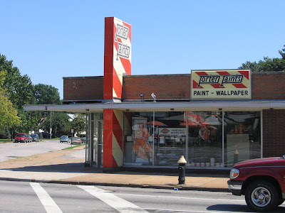
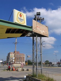
On the northwest tip of the Halls Ferry Circle stands a 1961-vintage building that was originally a Porter Paints store. As a kid in the backseat as we swung around The Circle, 2 buildings always got my attention: the Katz drugstore (now a Save-A-Lot) and this building when it was still all bright orange and cream.

It’s a huge plus that the building is still in use. A closer look at the vertical tower shows the covering coat of paint peeling away, and the classic Porter Paint logo peeking through.

Shortly after having snapped these photos, I got an e-mail from the manager of the Porter Paints store at Hampton & Eichelberger in South St. Louis, MO.

His store looked like this (above) before the remodel. After a green standing seam metal cap was placed atop this retail strip, the lower half is all that remains of the iconic Porter tower. Do you want to know what became of the rectangle sign seen to the right?

It’s now in my backyard! The store manager had salvaged the sign during the remodel, and held onto it for all this time. Having run across this blog entry, he thought I might be interested in having it. He was absolutely correct about that. Huge gold stars to Jonathan Tag for
A. being so cool as to save the sign
B. finding me through a Google search and
C. giving me the sign.
Thank you, Mr. Tag!!

The JC Penney Building and Aldermanic Ego

Martin Luther King Jr. Drive between Hamilton & Hodiamont
Wellston, MO
I have touched on this building inside a previous post. If you have ever run across it in your travels, bet it’s seared in your memory. It’s a singular building both in its neighborhood and in our city. Architects travel from out of town to see this Le Corbu-like gem. It’s unique and spacious with plenty of options for future use. That’s why the man who owns it bought it, and that’s why he’s been working to get it registered for both state and federal historic tax credits. The photos you see here are part of the series that I took for the owner’s applications. I did them for only the cost of the prints; wish I could have done it for free. Anything to help this building stand and thrive. And that is now becoming a problem.

The owner keeps me filled in on the struggle between him and his alderman. Let’s keep this story as tight as possible:

In 2006, Alderman Jeffrey Boyd fully supported the Landmarks Association writing the historic register nomination for this building. By winter 2007, it was ready to go before the Missouri Advisory Council, but Ald. Boyd had it pulled from the line-up. Why?

Ald. Boyd had a friend who wanted to buy the building and tear it down. The owner would not sell to someone who wants to tear it down when he’s working to bring it back to life. This pissed off Boyd, who then had it yanked from all board reviews and has since blocked any type of progress on the building. Despite the alderman’s anger, the owner began in earnest to get the building listed and eligible for tax credits to protect his investment.

Despite the feud, the owner has placed the building on the February 2008 agenda of the State Historic Preservation Office.

And Alderman Boyd is calling everyone he can to get this nomination yanked, once again. To his credit, he’s been very honest about why he wants it yanked: he wants it demolished.

Some of the local offices he has called flat out refused his request. But there’s a healthy list of local and state offices Boyd has contacted who have yet to weigh in.

They need to hear from people other than Boyd, and they need to understand the basic facts:
An alderman would rather demolish and leave another vacant lot in Wellston than let the building’s owner work to improve it.

Has Boyd explained the logic behind his plan?
Does he have a plan for something to go in its place?
Does he have any other valid reasons why he opposes this building and its owner?
Is this aboveboard business or is this a personal pissing match driven by ego and emotion?

This building’s nomination goes before the Preservation board today, January 28th. It goes before the Missouri Advisory board on February 9th.

Below are the people you can e-mail with your thoughts about the matter. If this situation bothers you, please speak up. Again, they need to understand more about this building beyond the Owner vs. Alderman struggle. At the very least, illogical injustice needs to be exposed.

Kathleen Shea, Director
Cultural Resources Office
1015 Locust Street #1200
St. Louis, MO 63101
SheaK@stlouiscity.com

Tiffany Patterson, National Register Coordinator
State Historic Preservation Office
P.O. Box 176
Jefferson City, MO 65102
tiffany.patterson@dnr.mo.gov

Blairmont & Bohemian Hill


Between the above, and the Bohemian Hill fiasco, I have two questions for the people who run the city of St. Louis:

What century is it?
Where’s you’re civic self-esteem?

Re: Blairmont
I’m pretty sure it’s the 21st century, yet both city & state government is dangerously close to resurrecting 19th century Jim Crow Laws that were completely abolished in the latter 20th century. This potential regression into segregation is just as absurd as it is illegal.

Re: Bohemian Hill
There’s no denying that St. Louis City has come back to life, and it’s the unique aspects of this city that have been its resurrecting life force. Yet our civic leaders still carry on as if we have to beg and grovel to every Daddy Walgreens to have any chance at survival. Rather than plan and deal with a sense of purpose and confidence, their continual cave-ins to homogenous, corporate pressure just reveals a lack of respect for themselves, their city and the citizens who voted them in.

Fountain Park Demolition?

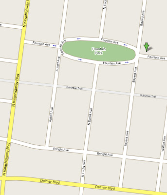
Fountain Park Neighborhood
North St. Louis, MO
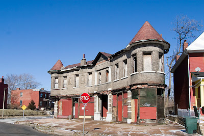
Some residential business brought me to this neighborhood for the first time, and I was enchanted. Even on a snowy, bitterly cold day I could imagine the beauty of the park during spring and summer, and the houses ringing it have a stately charm. Then I saw the building, above.

There’s an historic church from 1895 at the southwestern edge of the oval, the rest is single and multi-family residential, save for this mixed-use structure at the northeastern edge.

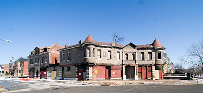
It was built in 1897, with store fronts at ground level and apartments above. The building curves to match the geometry of the neighborhood, and the cylindrical turrets are like lyrical bookends. I immediately imagined decades of people lounging in these spaces, gazing out over the park, and it felt magical.

The building is certainly not in the best shape. Scavengers have carted off most all the valuable pieces from ground level, and severe water damage is evident. But the building is far from down for the count, so I checked into its status.

City records show that it may have been vacant since 1989, and that the Citizen’s Service Bureau received 6 complaints on the building between June 2005 and November 2006, mostly about the vacant building being unsecured. The easy assumption is that the immediate neighbors keep an eye on it, and won’t tolerate any nonsense.


Exact sales information for the building is unavailable, but it is now owned by Titsworth Properties, LLC, out of downtown Clayton, and I get the impression from past permit applications that their ownership is fairly recent.

But the most curious part is that building was first condemned to be demolished in November 1996, and a new demo permit was issued in September of 2006. Which has me curious about:
Exactly how do demolition permits work?
Why did Titsworth buy a building that was to be demolished?
If it does finally go down, what will go in its place?

A 1979 survey tags the building as having “state significance,” and there’s no denying it’s an important – and gorgeous – part of the neighborhood. Whatever would replace it would surely be out of place with the rest of the area. Or even worse, it would just remain a blank hole in a neighborhood that has worked hard to retain most all of its original fabric.

I long to know about the history of this building and what’s planned for it in the present and future. If you have any of the information, please do share, and keep your fingers crossed that some kind of miracle keeps it standing with intent to thrive.

FOUND: Another Phillips 66 Bat Wing

Page Ave. & Vandeventer
North St. Louis, MO

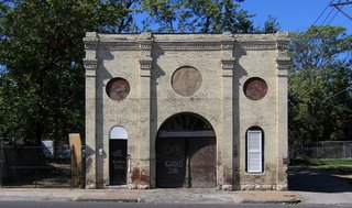
I was tooling down Vandeventer, and was captivated by the building, above (if anyone has info on it, please do share). Only when deciding to stop for more photos of it did I finally see what was across the street…

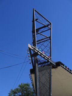
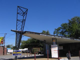
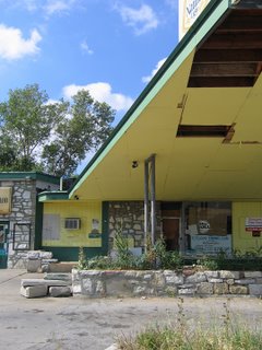
A previously unknown (to me) former Phillips 66, “bat wing” edition!!
The delight factor gets upped because it’s actually in use. Sure, it’s tricked out with all kinds of multi-colored lights and handmade plywood signs, but that proves its adaptability, and all the extra gewgaws don’t detract from the overall effect.

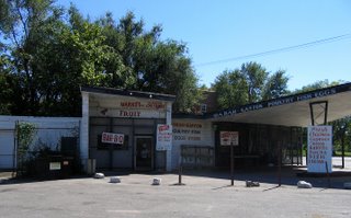
This Phillips 66 retains all of its original structure, doing business as Sarah Easton Poultry Fish & Egg Market. A small percentage of the avalanche of signage did tout the corner grocery aspect, but the main draw is food. Good-size lunch menu with BBQ, fresh coon and duck, “Fresh Fish, You Buy, We Fry” (click above photo to enlarge for details). What was once the car repair bay is now the take-out counter and kitchen. And there’s plenty of parking.

The majority of 66 Bat Wing’s still in use are in older, Blacker parts of town. There is one still in use as a car repair station at Chippewa & Mackland, in an older, Whiter part of South St. Louis. But the racial and financial politics of North City & County keeps the typical retail/residential developer from plowing everything over, thus allowing buildings like this to remain standing. And since they’re just standing there, why not use them?

I adore this organic form of “adaptive re-use.” It’s not planned, philosophized or politicized by university students and their professors in 100-page treatise that city planners will never bother to read. It just happens because everyone’s left alone to morph naturally. And a building previously designed in the late 1950s to purposely accommodate cars is still going to work in the 21st century, no matter what the new contents. Another case in point being…

Missouri Avenue & 6th Street
East St. Louis, IL
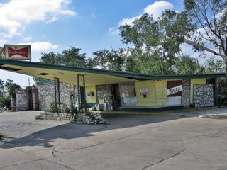
This one is not a new find, just one that’s taken awhile to get proper photos of. And while waiting for that moment to happen, the place finally closed for good.

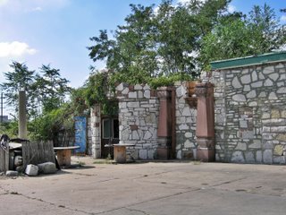
This Phillips 66 became a catch-all quick shop and liquor store, but the owner spent a lot of time personalizing the site. He turned the repair bays into retail space, covered the original concrete block with stone, created stone planters around the bases of the metal, lattice-work columns and formed an architectural salvage museum…

As nearby buildings were demolished, the owner snagged them for what had to be purely sentimental reasons. The red granite columns (above, center) came from the Tresh Neon Sign Co. building, while the rest of the pieces were taken from the former East St. Louis Public Library. Both buildings were within several blocks of the gas station, and torn down in the late 1980s.

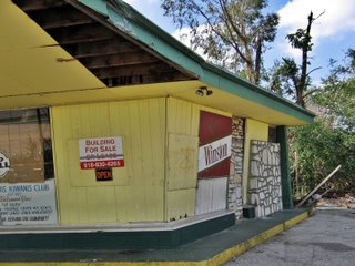
It’s assumed the owner has since died, which is why the place went from “For Sale Or Lease” to simply “For Sale” (above photo).

Odd Coincidence: Shortly after taking these East STL photos, I got an e-mail from a man near Kansas City, MO who had just seen my post about the Rockhill Double Bat Wings going down. Seems he’d love to buy one of these buildings to rehab and re-use. Did I know of any available?

It also reminded me of other readers’ comments that a Bat Wing would convert into a killer bicycle repair/sales shop or a hot dog stand. These uniquely shaped and detailed buildings do capture ones imagination, and the ones still working proves they’re easy to convert into whatever function you need it to serve.

RELATED
Phillips 66, Part One
Phillips 66, Part Two
R.I.P. Phillips 66

Cycling & Religion


At the southern-most start of the Riverfront bike trail stand these majestic piles of…what? Not sand…the white pile looks like finely ground rock. But the blue pile? I just don’t yet know what they are. Anyway, the sheer height and weight of the white mountain against a gorgeous azure and fluffy white sky was a spiritual moment, and reminded me of this:

Church roof at Old Halls Ferry & Redman Road
Black Jack, MO
The church has changed names and denominations many times over the years, so forgive me for not keeping track of proper names. This roof is a North County landmark, especially at Christmas time, when spotlights alternate green and red across the spires. To those of us who grew up in North County, we took this futuristic sight for granted. It was simply a natural part of the topography, much like the big white pile on the bike trail. Biking and religion made a connection in my heart, now a convert.

In that vein, the Urban Review has a fine series of what I call “The Bike Rack Rants.” I’ve assembled the results; it’s an entertaining must-read for urban bikers.

Fill in the Blank


Ecology Of Absence found the above in August of 2004, and wrote that if anyone had any other info or photos, please contribute.
Eureka!
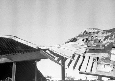
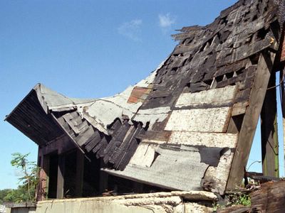
In September & October of 2003, I obsessed over these remains, trying to take THE perfect shot of it. The swoop and flow of that roof was so poetic. But be it black & white or color film, morning or afternoon light, I just couldn’t properly capture the sad, suspended drama of it.
I felt a slight sense of relief when the east half of the roof finally slumped to the ground. I could let go of the impossible shot.

photo by toby weiss
P.S. to EOA: I also have a shot of the mural. I lived across the street from it (above what is now The Royale) for 4 years. It’s buried in a pile of photos from the mid ’90s. When I get the courage to do the time warp again, I’ll pass along the memory of the mural’s florid beauty.